
DIGITAL SURF
France
Dedicated imaging, analysis and metrology software for scanning 3D surface profilometers using contact or non-contact techniques - including stylus profilers, laser triangulation profilers, confocal point sensor profilers, auto-focus profilers and white light interferometers Compatible with all scanning 3D surface profilometers used for surface analysis and metrology. Real time 3D imaging of surface topography - at any zoom level, angle and height amplification. Correct measurement artifacts - spikes, anomalous scan lines, missing data points, tip impact. Analyze surface geometry - distances, angles, areas, volumes, step heights, coplanarity. Apply advanced roughness/waviness filtering techniques - defined in ISO 16610. Analyze surface texture - in accordance with the latest ISO and national standards, including ISO 25178 and ISO 4287. Extract and analyze sub-surfaces - study them just like full measured surfaces. Increase profilometer vertical range virtually in software - combine measurements made at different heights. Easy integration into lab and production environments - export of all numerical results. Add optional modules for advanced surface texture and form analysis, contour analysis, grains and particles analysis, FFT-based analysis and more.
DIGITAL SURF
France
Dedicated surface imaging, analysis and metrology software for 3D optical microscopes and profilers measuring topography - confocal microscopes, interferometric microscopes, digital holographic microscopes, focus variation microscopes & structured light systems Compatible with all 3D optical profilers and microscopes used for surface analysis and metrology. Real time imaging of 3D surface topography with near-perfect lighting. 3D surface overlays for fast feature location - overlay color and intensity images on 3D topography. Remove data acquisition artifacts - outliers, local defects. Increase field of view virtually - assemble measurements using surface topography stitching. Analyze roughness and surface texture - in accordance with the latest ISO and national standards. Analyze surface geometry - including volume of surface structures (bumps, holes), step heights. Extract and analyze regions of interest - study them in the same way as full measured surfaces. 3D reconstruction of multi-focus images - reconstruct 3D topography from multi-focus image stacks. Easy integration into lab and production environments - export of all numerical results. Easy publication - export analysis documents, pages and individual images up to 1200 dpi. Add optional modules for advanced surface texture analysis, contour analysis, grains and particles analysis, 3D Fourier analysis, image co-localization, statistics and more.
HELICEO
France
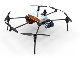
Its solid structure and in-flight stability allows its use on a wide variety of sites. Fully automatic, the Fox6 can carry out photogrammetry missions of up to 1.5 km². It is the perfect tool for large scale mapping missions as well as for static work and volume measurements. Thanks to its HD sensor and compatibility with DroneBox RTK, the Fox6 provides high precision for georeferenced photo collages, orthophotos, point clouds and DTMs / DSMs. This drone is made for professionals of the measurement such as surveyors, topographers, archaeologists and responsible for quarries or mines.

Do you sell or make similar products?
Sign up to europages and have your products listed
Results for
Topography - Import exportNumber of results
3 ProductsCompany type
Category