
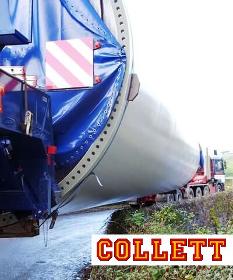
COLLETT & SONS LTD
United Kingdom

> Click on the "WEBSITE" link for more > Our Transport Consulting experts possess the knowledge, experience and skills to analyse the surrounding topography and the impact of abnormal loads & heavy transport projects on the surrounding environment. Collett Transport Consulting topographical surveys are used to map the contours of the ground and existing features to assist with route planning and necessary modifications for abnormal load & heavy transport projects. This process, undertaken in the early days of our planning allows us to identifying any features which which could potentially impact on any abnormal load or heavy transport projects. The data gathered by Collett Transport Consulting from site visits and swept path analysis, coupled with data gathered during topographical surveys, provides the most accurate indication of any third party land requirements, road widening or pinch points along the route.
COLLETT & SONS LTD
United Kingdom
> Click on the "WEBSITE" link for more > Our Consulting Team has a proven track record in providing specialist reports to facilitate safe and professional transport. Our team of highly trained, experienced professionals can analyse the impact of abnormal loads on the surrounding environment identifying any amendments which may be required for safe passage. Possessing detailed knowledge of our specialist tractors, trailers and SPMTs, we apply the practical transport considerations of abnormal load vehicles. Our team understands the behaviour of abnormal load vehicles and has extensive knowledge of transport regulations, environmental considerations and planning requirements. For Heavy Transport projects we routinely undertake Route Access Surveys, Swept Path Analysis, Topographical Surveys, Traffic Management Plans, Visual Route Inspections, Test Drives and Environmental Impact Assessments.

KNIGHT OPTICAL (UK) LTD
United Kingdom
Knight Optical offer a range of Stock Sapphire Windows, and custom for use within Airborne LiDAR Systems. These are systems used in surveying for topographical measurements. The data accumulated can be used to generate a Digital Terrain Model or a Digital Elevation Model which are 3D representations of terrain. Sapphire (Al2O3) is one of the hardest minerals and optical materials available for use in the range from UV up to 5µm. Making it ideal as a protective window for airborne systems which may be utilised in harsh environment or against birds! Sapphire is grown by various methods from seed samples. Sapphire can be polished to a high standard, but as it is the second hardest mineral on Earth it must be subject to high forces to polish. Therefore, windows made from Sapphire must have a thickness to diameter ratio of at least 10:1, that is, greater For more information read PDF….

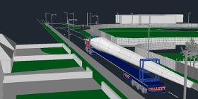
COLLETT & SONS LTD
United Kingdom
> Click on the "WEBSITE" link for more > Traffic management plans ensure that not only do heavy transport & abnormal load projects minimise impact on the surrounding environment but also on other road users and pedestrians. Traffic management plans include TTRO (Temporary Traffic Regulation Order), route planning and access reports to plan the movement of abnormal load heavy transport projects. Utilising all the data collated whilst undertaking swept path analysis reports, topographical surveys, visual route inspections, route access surveys and test drives, our Transport Consulting Team will provide comprehensive traffic management plans detailing all aspects of your heavy transport project. These traffic management plans and heavy transport surveying services identify current heavy transport legislation applicable to each individual abnormal load project.
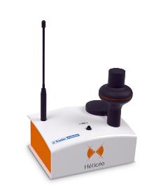
HELICEO
France
Hélicéo created the DroneBox technology in order to meet the demands of professionals for multiple applications as well as to address the economic challenge of needing multiple types tools. This “Plug & Play” device is adaptable across Hélicéo’s entire range of products, allowing you to perform precision measurement with multiple vehicles and sensors while reducing your investment. The DroneBox, which may be used onboard any Hélicéo vehicle, uses Network Real Time Kinematic (NRTK or RTK) technology, thus providing precision measurement using satellite corrections in real time in order to achieve precision measurement to centimeter accuracy. DroneBox has the following integrated key functions: GNSS geodetic mapping, autopilot, telemetry, archiving, communication, flight controller and avionics.

Do you sell or make similar products?
Sign up to europages and have your products listed
Results for
Topographic survey - Import exportNumber of results
5 ProductsCountries
Company type