

ROLATUBE TECHNOLOGY LTD
United Kingdom

THIS TRIPOD IS NOT TELESCOPIC - INSTEAD IT USES A UNIQUE ROLLABLE COMPOSITE. TRIED AND TESTED BY THE MILITARY FOR 20+ YEARS, NOW AVAILABLE TO NON-MILITARY CUSTOMERS. Using the unique Rolatube rollable composite for the legs, the ICT is able to roll up into the smallest pack size. With a choice of legs of 650mm or 1250mm in length, this small but mighty tripod can take top loads of up to 40kg. Optional accessories include peg plates and pegs or foot spikes, so your valuable equipment is secure and stable. The, when you're done, roll it all up and move on.
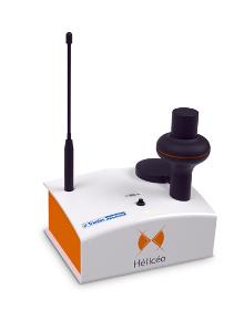
HELICEO
France
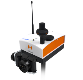
Hélicéo created the DroneBox technology in order to meet the demands of professionals for multiple applications as well as to address the economic challenge of needing multiple types tools. This “Plug & Play” device is adaptable across Hélicéo’s entire range of products, allowing you to perform precision measurement with multiple vehicles and sensors while reducing your investment. The DroneBox, which may be used onboard any Hélicéo vehicle, uses Network Real Time Kinematic (NRTK or RTK) technology, thus providing precision measurement using satellite corrections in real time in order to achieve precision measurement to centimeter accuracy. DroneBox has the following integrated key functions: GNSS geodetic mapping, autopilot, telemetry, archiving, communication, flight controller and avionics.
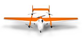
HELICEO
France
FoxyPro is a fully automatic VTOL airplane created for long distance photogrammetry surveying. Available with a wingspan of 3 m or 3.5 m, FoxyPro is equipped with a vertical takeoff and landing system (VTOL), allowing it to take off and land on all types of sites. Thanks to its great in-flight stability, FoxyPro has a maximum load of 2 kg, allowing it to carry an HD sensor. With more than an hour of in-flight battery life, FoxyPro is capable of scanning up to 300 ha (741 acres) in a single mission. This drone is made for professionals of the measurement such as surveyors, topographers, archaeologists and responsible for quarries or mines.
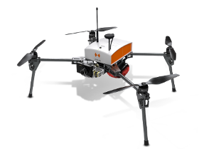
HELICEO
France
Its light structure and engine allow for extreme maneuverability with manual piloting. Designed for automatic photogrammetry missions up to 1.5 km², Fox4 may also carry out missions for inspection of infrastructure, structures, network lines or industrial sites, in automatic or manual mode. Perfect for your daily mapping missions and calculations of cubature, this quadcopter allows for photo collages, georeferenced orthophotos and point clouds as well as DTM / DSM. This drone is made for professionals of the measurement such as surveyors, topographers, archaeologists and responsible for quarries or mines.
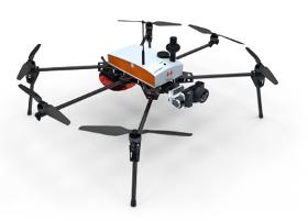
HELICEO
France
Its solid structure and in-flight stability allows its use on a wide variety of sites. Fully automatic, the Fox6 can carry out photogrammetry missions of up to 1.5 km². It is the perfect tool for large scale mapping missions as well as for static work and volume measurements. Thanks to its HD sensor and compatibility with DroneBox RTK, the Fox6 provides high precision for georeferenced photo collages, orthophotos, point clouds and DTMs / DSMs. This drone is made for professionals of the measurement such as surveyors, topographers, archaeologists and responsible for quarries or mines.

Do you sell or make similar products?
Sign up to europages and have your products listed
HELICEO
France
FoxyWalk is a platform for easy terrestrial photogrammetry. It is aimed towards surveyors, topographers, architects, archaeologists. It allows the shooting of photos which would be inaccessible from the sky (facades, arches, etc.) and creation of 3D models. Perfect for complementary data acquisition of a drone survey. Terrestrial photogrammetry allows the survey of the shape and dimensions of inaccessible objects, study of deformations and analysis of structural anomalies. It may also be used in determining volumes. Terrestrial photogrammetry applications are varied : Reconstruction of facades, heritage conservation, monitoring structures and sites as well as supplementing aerial surveys and surveys of routes, ditches and open trenches with georeferencing networks (DT-DICT).
STL SYSTEMS AG
Switzerland
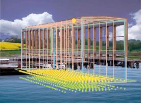
Stationary ship will be treated and ranged by magnetic deperming range in a cage System for the demagnetization of naval ships and subsequent magnetic surveying on a magnetic demagnetization and surveying equipment installed within a cage type frame, with the special feature that the ship is stationary during the entire treatment process similar to the earth magnetic simulator of German Navy. Treatment and magnetic measurement of Navy vessels in combination with time optimzed and area economy lead to a range that combines the advantages of ODMR and HDMR, where all system entities are installed on a frame around the vessel undergoing ranging and treating. Above sketch shwos the ODMR combining simulation and deperming coil system integrated on a cage type building, which can be installed on any harbour or Navy area. Pricing may vary depending on cable length, available power supply and required magnetic field.
STL SYSTEMS AG
Switzerland
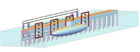
System for the demagnetization of naval ships and subsequent magnetic surveying on a magnetic demagnetization and surveying equipment installed on a pier, with the special feature that the ship is stationary during the entire treatment process. Treatment and magnetic measurement of Navy vessels in combination with low cost and area economy lead to a range that combines the advantages of ODMR and CDMR, where all system entities are installed vertically on a low-level magnetic jetty or pier. STL has developed this idea becoming the Half-Space Deperming Range (HDMR) providing cost and time effective deperming and measurement processes for Navy vessels with an optimal benefit-cost-ratio. Above sketch shwos the HDMR combining simulation and deperming coil system integrated on an existing jetty.

Results for
Surveying equipment - Import exportNumber of results
10 ProductsCountries
Company type