
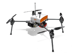
HELICEO
France
Its light structure and engine allow for extreme maneuverability with manual piloting. Designed for automatic photogrammetry missions up to 1.5 km², Fox4 may also carry out missions for inspection of infrastructure, structures, network lines or industrial sites, in automatic or manual mode. Perfect for your daily mapping missions and calculations of cubature, this quadcopter allows for photo collages, georeferenced orthophotos and point clouds as well as DTM / DSM. This drone is made for professionals of the measurement such as surveyors, topographers, archaeologists and responsible for quarries or mines.
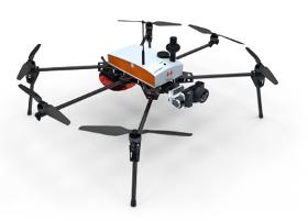
HELICEO
France
Its solid structure and in-flight stability allows its use on a wide variety of sites. Fully automatic, the Fox6 can carry out photogrammetry missions of up to 1.5 km². It is the perfect tool for large scale mapping missions as well as for static work and volume measurements. Thanks to its HD sensor and compatibility with DroneBox RTK, the Fox6 provides high precision for georeferenced photo collages, orthophotos, point clouds and DTMs / DSMs. This drone is made for professionals of the measurement such as surveyors, topographers, archaeologists and responsible for quarries or mines.

Do you sell or make similar products?
Sign up to europages and have your products listed
Results for
Photo point - Import exportNumber of results
2 ProductsCountries
Company type
Category