
HELICEO
France
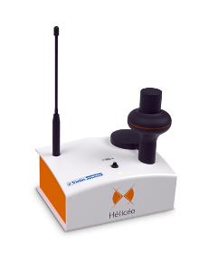
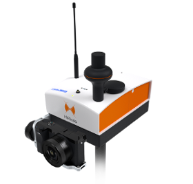
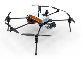
Hélicéo created the DroneBox technology in order to meet the demands of professionals for multiple applications as well as to address the economic challenge of needing multiple types tools. This “Plug & Play” device is adaptable across Hélicéo’s entire range of products, allowing you to perform precision measurement with multiple vehicles and sensors while reducing your investment. The DroneBox, which may be used onboard any Hélicéo vehicle, uses Network Real Time Kinematic (NRTK or RTK) technology, thus providing precision measurement using satellite corrections in real time in order to achieve precision measurement to centimeter accuracy. DroneBox has the following integrated key functions: GNSS geodetic mapping, autopilot, telemetry, archiving, communication, flight controller and avionics.
HELICEO
France
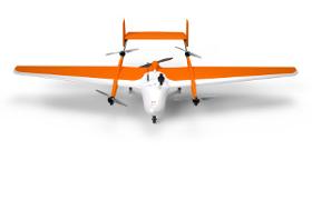
FoxyPro is a fully automatic VTOL airplane created for long distance photogrammetry surveying. Available with a wingspan of 3 m or 3.5 m, FoxyPro is equipped with a vertical takeoff and landing system (VTOL), allowing it to take off and land on all types of sites. Thanks to its great in-flight stability, FoxyPro has a maximum load of 2 kg, allowing it to carry an HD sensor. With more than an hour of in-flight battery life, FoxyPro is capable of scanning up to 300 ha (741 acres) in a single mission. This drone is made for professionals of the measurement such as surveyors, topographers, archaeologists and responsible for quarries or mines.
HELICEO
France
FoxyWalk is a platform for easy terrestrial photogrammetry. It is aimed towards surveyors, topographers, architects, archaeologists. It allows the shooting of photos which would be inaccessible from the sky (facades, arches, etc.) and creation of 3D models. Perfect for complementary data acquisition of a drone survey. Terrestrial photogrammetry allows the survey of the shape and dimensions of inaccessible objects, study of deformations and analysis of structural anomalies. It may also be used in determining volumes. Terrestrial photogrammetry applications are varied : Reconstruction of facades, heritage conservation, monitoring structures and sites as well as supplementing aerial surveys and surveys of routes, ditches and open trenches with georeferencing networks (DT-DICT).
HELICEO
France
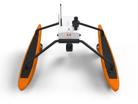
FoxBathy is an automatic bathymetric drone catamaran with double electric propulsion, which allows productivity, safety and precision in aquatic surveying. It ensures the safety of the operator, who may remain on the bank thanks to fully automated steering. FoxBathy not only helps in monitoring ports, marinas, sea areas, rivers, creeks, lakes and ponds or lagoons but also helps to identify critical areas or dangerous objects for navigation. Finally, it allows periodic monitoring of siltation and supervision of marine sites by performing calculations of cubatures and editing DTMs (Digital Terrain Models).
HELICEO
France
Its solid structure and in-flight stability allows its use on a wide variety of sites. Fully automatic, the Fox6 can carry out photogrammetry missions of up to 1.5 km². It is the perfect tool for large scale mapping missions as well as for static work and volume measurements. Thanks to its HD sensor and compatibility with DroneBox RTK, the Fox6 provides high precision for georeferenced photo collages, orthophotos, point clouds and DTMs / DSMs. This drone is made for professionals of the measurement such as surveyors, topographers, archaeologists and responsible for quarries or mines.

Do you sell or make similar products?
Sign up to europages and have your products listed

SYMBIAL SAS
France
MARKET RESEARCH AND MARKETING Audits We conduct in-depth interviews with a panel of your customers (current and former). This process is mainly implemented face-to-face, based on an interview guide. We provide you with an in depth assessment and recommendations to increase your customers’ loyalty. Survey We help you or carry out client questionnaires either online, by telephone, face to face or by mail courrier. This is a quantitative type of collection, which can complement a qualitative audit. We provide you with a report on your strengths and weaknesses, with explanations given by the clients. We make a series of recommendations to improve client satisfaction. This can ideally take place in the form of barometre (annual or more rarely). Mystery visits CThis approach can help to understand which parts of the customer relationship need to be improved. We visit your shops or counters, call your customer relations centres, your after-sales services, based on an objective measurement.
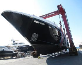
INTERFACE MARINE SURVEYORS
France
Registered Marine Surveyors. Interface Marine offers a flexible, common sense approach to surveying Yachts of any size. WHAT WE DO: We help owners, buyers, brokers and marine professionals achieve positive outcomes to their projects by giving a concise and in-depth analysis of a vessel’s condition along with clear and constructive recommendations. WHY YOU SHOULD WORK WITH US: Interface Marine is well connected to any destination in Europe via Nice airport and 30 mins from most Riviera Ports & within one hour to Monaco, or the Italian Riviera. WHAT MAKES US DIFFERENT: Proven expertise with a flexible & committed approach to every project achieving the tightest schedules with positive solutions. Our qualified team Survey vessels from the largest of super yachts to the smallest of runabouts.
Results for
Surveys - Import exportNumber of results
8 ProductsCountries
Company type