
HELICEO
France
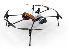
Its solid structure and in-flight stability allows its use on a wide variety of sites. Fully automatic, the Fox6 can carry out photogrammetry missions of up to 1.5 km². It is the perfect tool for large scale mapping missions as well as for static work and volume measurements. Thanks to its HD sensor and compatibility with DroneBox RTK, the Fox6 provides high precision for georeferenced photo collages, orthophotos, point clouds and DTMs / DSMs. This drone is made for professionals of the measurement such as surveyors, topographers, archaeologists and responsible for quarries or mines.
HELICEO
France
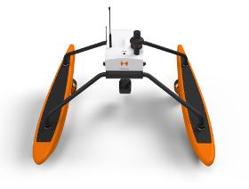
FoxBathy is an automatic bathymetric drone catamaran with double electric propulsion, which allows productivity, safety and precision in aquatic surveying. It ensures the safety of the operator, who may remain on the bank thanks to fully automated steering. FoxBathy not only helps in monitoring ports, marinas, sea areas, rivers, creeks, lakes and ponds or lagoons but also helps to identify critical areas or dangerous objects for navigation. Finally, it allows periodic monitoring of siltation and supervision of marine sites by performing calculations of cubatures and editing DTMs (Digital Terrain Models).
HELICEO
France
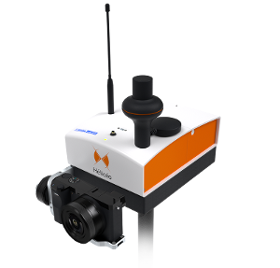
FoxyWalk is a platform for easy terrestrial photogrammetry. It is aimed towards surveyors, topographers, architects, archaeologists. It allows the shooting of photos which would be inaccessible from the sky (facades, arches, etc.) and creation of 3D models. Perfect for complementary data acquisition of a drone survey. Terrestrial photogrammetry allows the survey of the shape and dimensions of inaccessible objects, study of deformations and analysis of structural anomalies. It may also be used in determining volumes. Terrestrial photogrammetry applications are varied : Reconstruction of facades, heritage conservation, monitoring structures and sites as well as supplementing aerial surveys and surveys of routes, ditches and open trenches with georeferencing networks (DT-DICT).

Do you sell or make similar products?
Sign up to europages and have your products listed
Results for
Surveying with special equipment - Import exportNumber of results
3 ProductsCountries
Company type
Category