


TOTALENERGIES LUBRIFIANTS
France
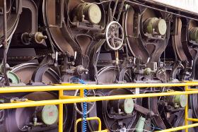
Plain or rolling bearings and medium-loaded gears subjected to considerable temperature constraints. Drying cylinder bearings for papermaking machines. Hydraulic circuits in variable crown cylinders.
TOTALENERGIES LUBRIFIANTS
France
Plain or rolling bearings and medium-loaded gears subjected to considerable temperature constraints. Recommended for drying cylinder bearings for papermaking machines.

Do you sell or make similar products?
Sign up to europages and have your products listed
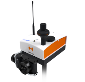
HELICEO
France
FoxyWalk is a platform for easy terrestrial photogrammetry. It is aimed towards surveyors, topographers, architects, archaeologists. It allows the shooting of photos which would be inaccessible from the sky (facades, arches, etc.) and creation of 3D models. Perfect for complementary data acquisition of a drone survey. Terrestrial photogrammetry allows the survey of the shape and dimensions of inaccessible objects, study of deformations and analysis of structural anomalies. It may also be used in determining volumes. Terrestrial photogrammetry applications are varied : Reconstruction of facades, heritage conservation, monitoring structures and sites as well as supplementing aerial surveys and surveys of routes, ditches and open trenches with georeferencing networks (DT-DICT).
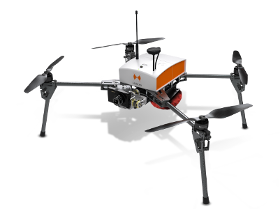
HELICEO
France
Its light structure and engine allow for extreme maneuverability with manual piloting. Designed for automatic photogrammetry missions up to 1.5 km², Fox4 may also carry out missions for inspection of infrastructure, structures, network lines or industrial sites, in automatic or manual mode. Perfect for your daily mapping missions and calculations of cubature, this quadcopter allows for photo collages, georeferenced orthophotos and point clouds as well as DTM / DSM. This drone is made for professionals of the measurement such as surveyors, topographers, archaeologists and responsible for quarries or mines.
Results for
Maps - Import exportNumber of results
8 ProductsCountries
Company type