
HELICEO
France
FoxyWalk is a platform for easy terrestrial photogrammetry. It is aimed towards surveyors, topographers, architects, archaeologists. It allows the shooting of photos which would be inaccessible from the sky (facades, arches, etc.) and creation of 3D models. Perfect for complementary data acquisition of a drone survey. Terrestrial photogrammetry allows the survey of the shape and dimensions of inaccessible objects, study of deformations and analysis of structural anomalies. It may also be used in determining volumes. Terrestrial photogrammetry applications are varied : Reconstruction of facades, heritage conservation, monitoring structures and sites as well as supplementing aerial surveys and surveys of routes, ditches and open trenches with georeferencing networks (DT-DICT).
HELICEO
France
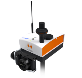
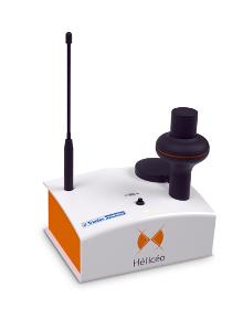
Hélicéo created the DroneBox technology in order to meet the demands of professionals for multiple applications as well as to address the economic challenge of needing multiple types tools. This “Plug & Play” device is adaptable across Hélicéo’s entire range of products, allowing you to perform precision measurement with multiple vehicles and sensors while reducing your investment. The DroneBox, which may be used onboard any Hélicéo vehicle, uses Network Real Time Kinematic (NRTK or RTK) technology, thus providing precision measurement using satellite corrections in real time in order to achieve precision measurement to centimeter accuracy. DroneBox has the following integrated key functions: GNSS geodetic mapping, autopilot, telemetry, archiving, communication, flight controller and avionics.

Do you sell or make similar products?
Sign up to europages and have your products listed
Results for
Gps surveys - Import exportNumber of results
2 ProductsCountries
Company type
Category